|
|
Post by missouriboy on Apr 29, 2023 15:29:41 GMT
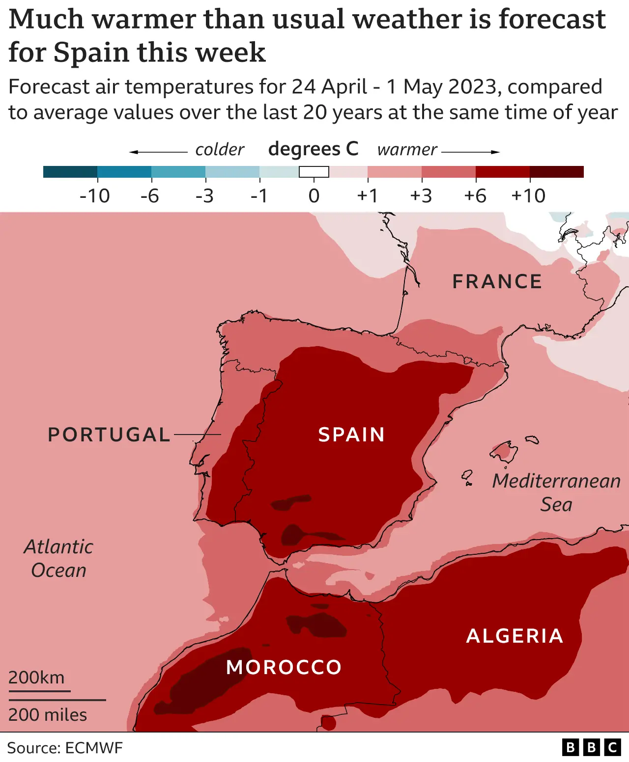
This may be a major issue this summer. The BBC is already leading the charge. It is a good opportunity to track the major climate/weather variables and try to explain what happens with reference to ongoing indicators. So I gave it its own thread. Expect the BBC and others to rally Charles Oscar's climate warriors for a massive assault on science logic. Survivors will be laughed at.  Reference to last year by the BBC - www.bbc.com/news/world-europe-62707435 |
|
|
|
Post by missouriboy on Apr 29, 2023 16:36:38 GMT
I will start this out by looking at historic changes in surface pressure patterns which have been used to construct the North Atlantic Oscillation (NAO) Index. Surface pressure pattern setups, as defined by transects between (1)Iceland and Gibraltar and (2)Iceland and the Azores have been used to identify periods of zonal and meridional flow in the atmosphere. A positive NAO generally results in the former, and a negative NAO results in the later. And the later generally results in southward penetration of cold Arctic air to the south. Large negative NAO periods tend to be associated with periods of low solar activity. You can see those associated with our current SC25 minimum, the SC24 minimum, the 1960s-70s minimum, the 1870s-80s Centennial minimum and the exit slope of the Dalton Minimum (ca. 1820). I need to add a winter and summer version of this graph. Examples of Drought across these periods You may note their long-term projections. 
All territories of Spain are subject to droughts to some degree given the location of the country to the south of the westerlies,[1] although their impact and frequence is uneven. Droughts occur when precipitation is considerably reduced during the theoretically rainy months of the year.[2]
Four types of climatic droughts can be defined: Cantabrian (coyuntural and low-frequence droughts), Iberian (droughts usually affecting the entire Iberian Peninsula, except the Cantabrian façade), southeastern (structural droughts, the mirror opposite of the Cantabrian ones) and Canarian droughts.[3]
The drought, along with high winds and fallen cables, is being looked at as a prime causal factor in forest fires.[4]
In 2012 Spain experienced the driest period since the 1940s, with rainfall decreased by up to 75%.[4]
Most rain in Spain falls in the winter as wet, low-pressure systems coming from the Atlantic Ocean, but a high-pressure system called the Azores high can block these weather fronts coming from the Atlantic Ocean (Carrington, 2022). From 1850 to 1980, the frequency of this high-pressure system, Azores High, was once every seven years. But data has shown that after 1980 the frequency became once every four years. The problem of the Azores high is that it reduces about one third of the monthly rainfall in the winters (Carrington, 2022).
Since the industrial revolution, the Azores high, which is also called the Gatekeeper of European Rainfall has become more frequent. Research has shown that the Azores High has expanded as the earth has warmed (Tandon, 2022). The expansion of the Azores High will intensify the drought in Portugal and Spain, and it's expected that these two regions will see a 10-20% drop in winter precipitation in upcoming winters (Tandon, 2022).
|
|
|
|
Post by missouriboy on Apr 29, 2023 17:50:04 GMT
Temperatures in Spain rose even higher on April 26, with 37.3 °C (99.1 °F) recorded in El Granado, 37.1 °C (98.7 °F) in Moron de la Frontera, 37.0 °C (98.6 °F) in Seville, 36.7 °C (98 °F) in Ecija, 36.6 °C (97.8 °F) in Cordoba, 35.8 °C (96.4 °F) in Huelva, 34.4 °C (93.2 °F) in Granada, and 33.4 °C (92.1 °F) in Badajoz, according to weather historian Maximiliano Herrera.
Bummer of a place name.
|
|